Cambrin
Cambrin | |
|---|---|
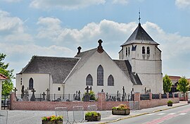
 The church of Cambrin | |
| Coordinates: 50°30′43″N 2°44′36″E / 50.5119°N 2.7433°E | |
| Country | France |
| Region | Hauts-de-France |
| Department | Pas-de-Calais |
| Arrondissement | Béthune |
| Canton | Douvrin |
| Intercommunality | CA Béthune-Bruay, Artois-Lys Romane |
| Government | |
| • Mayor (2020–2026) | Philippe Drumez[1] |
| Area 1 | 1.77 km2 (0.68 sq mi) |
| Population (2021)[2] | 1,228 |
| • Density | 690/km2 (1,800/sq mi) |
| Time zone | UTC+01:00 (CET) |
| • Summer (DST) | UTC+02:00 (CEST) |
| INSEE/Postal code | 62200 /62149 |
| Elevation | 19–31 m (62–102 ft) (avg. 30 m or 98 ft) |
| 1 French Land Register data, which excludes lakes, ponds, glaciers > 1 km2 (0.386 sq mi or 247 acres) and river estuaries. | |
Cambrin (French pronunciation: [kɑ̃bʁɛ̃]) is a commune in the Pas-de-Calais department in the Hauts-de-France region of France.[3]
Geography
[edit]A farming and light industrial village some 5 miles (8.0 km) east of Béthune and 18 miles (29 km) southwest of Lille, at the junction of the D166 and the N41 roads, by the banks of the small river Surgeon.
The marshes of Cambrin are an area of ponds and swamps bordering the communes of Cuinchy and Annequin. They cover 22 hectares and are open to the public. This natural space is managed by the Nature Conservatory Sites of Nord and Pas-de-Calais.[4]
As fenland, it plays a major ecological function for the water for the town and surrounding area and contributes to reducing the pollution of surface water.
The marshes, which had formerly been used to pump cooling water to the power station of Violaines, consists of a vast wooded wetland. The place is so attractive that a discovery trail has been created for visitors to enjoy their natural heritage. Many species of birds may be observed along this path.
Population
[edit]| Year | Pop. | ±% p.a. |
|---|---|---|
| 1968 | 791 | — |
| 1975 | 814 | +0.41% |
| 1982 | 740 | −1.35% |
| 1990 | 844 | +1.66% |
| 1999 | 957 | +1.41% |
| 2007 | 1,003 | +0.59% |
| 2012 | 977 | −0.52% |
| 2017 | 1,244 | +4.95% |
| Source: INSEE[5] | ||
Places of interest
[edit]- The church of Notre-Dame, rebuilt along with the rest of the village, after the First World War.
- The Commonwealth War Graves Commission cemeteries.
- The war memorial, one of seven replicas (in France) of Bartholdi's Statue of Liberty.
See also
[edit]References
[edit]- ^ "Répertoire national des élus: les maires" (in French). data.gouv.fr, Plateforme ouverte des données publiques françaises. 13 September 2022.
- ^ "Populations légales 2021" (in French). The National Institute of Statistics and Economic Studies. 28 December 2023.
- ^ INSEE commune file
- ^ "Conservatoire des Sites Naturels du Nord et du Pas de Calais". Archived from the original on 30 April 2010. Retrieved 17 November 2018.
- ^ Population en historique depuis 1968, INSEE
External links
[edit]- Official website of the village (in French)
- The CWGC extension to the communal cemetery
- The CWGC military cemetery


