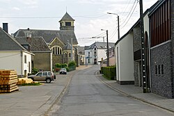
Vaux-sur-Sûre
Appearance
Vaux-sur-Sûre
Li Vå-so-Seure (Walloon) | |
|---|---|
 | |
| Coordinates: 49°55′N 05°35′E / 49.917°N 5.583°E | |
| Country | |
| Community | French Community |
| Region | Wallonia |
| Province | Luxembourg |
| Arrondissement | Bastogne |
| Government | |
| • Mayor | Yves Besseling (MR) |
| Area | |
| • Total | 135.72 km2 (52.40 sq mi) |
| Population (2018-01-01)[1] | |
| • Total | 5,651 |
| • Density | 42/km2 (110/sq mi) |
| Postal codes | 6640, 6642 |
| NIS code | 82036 |
| Area codes | 061 |
| Website | www.vaux-sur-sure.be |
Vaux-sur-Sûre (French pronunciation: [vo syʁ syʁ], Vaux on Sûre; Walloon: Li Vå-so-Seure) is a municipality of Wallonia located in the province of Luxembourg, Belgium.
On 1 January 2007 the municipality, which covers 135.87 km2, had 4,759 inhabitants, giving a population density of 35 inhabitants per km2.
The municipality consists of the following districts: Hompré, Juseret, Morhet, Nives, Sibret, and Vaux-lez-Rosières (town centre). Other population centers include:
- Assenois
- Belleau
- Bercheux
- Chaumont
- Chenogne
- Clochimont
- Cobreville
- Grandru
- Jodenville
- La Barrière
- Lavaselle
- Lescheret
- Mande-Sainte-Marie
- Morhet-Station
- Poisson-Moulin
- Remichampagne
- Remience
- Remoiville
- Rosières
- Salvacourt
- Sûre
- Villeroux
See also
[edit]References
[edit]- ^ "Wettelijke Bevolking per gemeente op 1 januari 2018". Statbel. Retrieved 9 March 2019.
External links
[edit] Media related to Vaux-sur-Sûre at Wikimedia Commons


